Table of Contents
- Version 1.75.0 - April 25, 2024
- Version 1.74.0 - April 25, 2024
- Version 1.73.0 - April 23, 2024
- Version 1.72.0 - April 19, 2024
- Version 1.71.1 - April 16, 2024
- Version 1.71.0 - April 11, 2024
- Version 1.70.0 - April 11, 2024
- Version 1.69.1 - April 10, 2024
- Version 1.69.0 - April 10, 2024
- Version 1.68.0 - April 09, 2024
- Version 1.67.0 - April 09, 2024
- Version 1.66.1 - April 04, 2024
- Version 1.66.0 - April 04, 2024
- Version 1.65.1 - April 03, 2024
- Version 1.65.0 - March 26, 2024
- Version 1.64.0 - March 26, 2024
- Version 1.63.1 - March 22, 2024
- Version 1.63.0 - March 20, 2024
- Version 1.62.1 - March 14, 2024
- Version 1.62.0 - March 14, 2024
- Version 1.61.0 - March 11, 2024
- Version 1.60.5 - March 08, 2024
- Version 1.60.4 - March 08, 2024
- Version 1.60.3 - March 07, 2024
- Version 1.60.2 - March 06, 2024
- Version 1.60.1 - March 05, 2024
- Version 1.60.0 - March 05, 2024
- Version 1.59.0 - March 04, 2024
- Version 1.58.3 - March 01, 2024
- Version 1.58.2 - February 29, 2024
- Version 1.58.1 - February 27, 2024
- Version 1.58.0 - February 27, 2024
- Version 1.57.2 - February 26, 2024
- Version 1.57.1 - February 23, 2024
- Version 1.57.0 - February 22, 2024
- Version 1.56.0 - February 21, 2024
- Version 1.55.0 - February 19, 2024
- Version 1.54.2 - February 19, 2024
- Version 1.54.1 - February 14, 2024
- Version 1.54.0 - February 08, 2024
- Version 1.53.0 - February 07, 2024
- Version 1.52.0 - February 06, 2024
- Version 1.51.0 - February 05, 2024
- Version 1.50.0 - January 31, 2024
- Version 1.49.1 - January 26, 2024
- Version 1.49.0 - January 25, 2024
- Version 1.48.1 - January 24, 2024
- Version 1.48.0 - January 23, 2024
- Version 1.47.4 - January 22, 2024
- Version 1.47.3 - January 18, 2024
- Version 1.47.2 - 2024-01-12
- Version 1.47.1 - 2024-01-12
- Version 1.47.0 - 2024-01-11
- Version 1.46.2 - 2024-01-11
- Version 1.46.1 - 2024-01-10
Version 1.75.0 – April 25, 2024 #
Changed
- Enhanced of Situm events:
- Create new events for destination reached or quit navigation. With these new events we will know when users arrive at their destination or leave the navigation
- Add device id field to both new and existing events. This will allow us to know the unique users that use each application.
- Add building id in app start event. Now we will know from which buildings our users start the application.
Version 1.74.0 – April 25, 2024 #
Added
- Implemented automatic and manual view reset and filters cleaning after a period of user inactivity.


Improved
- Enhanced Favorite POIs API:
- The update callback now exclusively displays favorite POIs for the current building, utilizing the new payload value: ‘currentPoiIdentifers’.
- The Favorite POIs endpoint for setting them now filters all sent POIs for the current building without affecting other buildings’ data.
Fixed
- Resolved bug causing duplicated POIs to appear when outdoor POIs were present.
Version 1.73.0 – April 23, 2024 #
Added:
- Images and Text on GeoJSON Features: We’ve added functionality to overlay images and text onto extruded GeoJSON features. This update makes it easier to identify shops and landmarks directly on the map, enhancing usability and visual appeal.
Fixed
- Fixed cartography.select_poi not selecting the destination floor.
- Fixed cartography.select_poi selecting while navigating towards some destination.
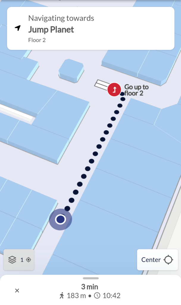
- Fixed a bug that provoked that if the destination of a route was immediately after a floor change, the destination floor and the associated Point of Interest (POI) for the floor change (stairs or elevator) were not correctly indicated.
Version 1.72.0 – April 19, 2024 #
Improved
- We’ve implemented enhancements to our navigation module to elevate the effectiveness of turn-by-turn navigation.
- We’ve revamped the appearance and user experience of our navigation screen for a more polished and intuitive interface.

Added
- We’ve added a new button that lets you start navigating directly from the Point of Interest information panel.
Changed
- We’ve made it easier to use the bottom drawer by:
- Letting the user expand it while filtering by category and viewing the map.
- Showing the expand bar only when there’s content in the bottom sheet.
- Now, the camera automatically follows the user under two scenarios:
- When the user changes floors during navigation.
- When the user first starts positioning.
Version 1.71.1 – April 16, 2024 #
Fixed
- Resolved issue where initial bottom drawer animations were ignored by delaying execution until the completion of an initial internal event.
- Avoid navigation mode interruption caused by a ‘ui.set_search_filter‘ action.
- Fixed ‘cartography.select_poi‘ automatically selecting the default floor.
Improved
- Enhanced the position layer by implementing custom rotation and radius animations, bypassing dependency on native transitions that caused issues on some cases.
Version 1.71.0 – April 11, 2024 #
Added
- Added functionality to the ‘ui.set_search_filter‘ message. This feature empowers users to conduct searches by text or category within the current building. Upon execution, this message triggers the bottom drawer to display matching search results.
Fixed
- Resolved a minor issue with search input length limitation.
Improved
- No logo is shown on the search bar: defaulted to whitelabel setting and attributed maps to Mapbox & Situm for enhanced clarity.
- We avoid location simulation conflicts with real-time positioning data. Previously, users using the simulation feature and real-time location might have seen spurious jumps.
Version 1.70.0 – April 11, 2024 #
Improved
- Improved the initial data loading process to optimize efficiency. Now, information is fetched only once, and we prefetch only the data that isn’t already stored.
Added
- We’ve introduced additional prefetch modes, providing flexibility in caching configurations. Now, the application can be configured to operate in one of the following modes:
- No prefetching: data is not prefetched.
- Minimal prefetching: Only essential data for the building currently displayed is prefetched. This includes points of interest, paths, floor images, the building’s GeoJSON, and details about the point of interest categories.
- Full prefetch: All relevant data for every building on the account is prefetched, encompassing points of interest, paths, floor images, each building’s GeoJSON, and point of interest categories.
Fixed
- Allow to load from the settings remote file the minimum radius information required to associate a Point of Interest (POI) with an indication.
- Avoid using safe top area padding on bottom drawer as it caused problems on some mobile platforms.
Version 1.69.1 – April 10, 2024 #
Changed
- Change feature editor shortcut to Ctrl+. and added search bar __editor to raise it
Version 1.69.0 – April 10, 2024 #
Changed
- Simulator no longer works as an “infinite” timer, but rather waits for the user
to press WASD keys on the keyboard. Keys are: W (forward), S (backward), A (left), D (right), E (floor up), Q (floor down).
Version 1.68.0 – April 09, 2024 #
Improved
- Updated WASM routes library
- Some navigation indications texts were changed to improve user experience.
- Changed icons and styles of some navigation indications.
- Now, we verify whether the user’s position has stabilized to use in indications, and utilize the yaw user position exclusively when the user needs to change direction
Fixed
- Remove shortest indications by configuration parameter.
Version 1.67.0 – April 09, 2024 #
Added
- Now, we display POIs “hidden”by the clusterization algorithm as dots in the map.

- New setting available: now, you may apply a fixed background color to all POIs (POI icon image needs to have a transparent background). The background size is also configurable.
Improved
- Removed location quality modal that prevented user from activating AR module when location was not accurate.
- Removed ‘zoom in hint animation’ that used to be shown
Version 1.66.1 – April 04, 2024 #
Fixed
- Addressed issue where certain Points of Interest configured to be hidden during search were not displayed when filtering POIs by favorites.
Version 1.66.0 – April 04, 2024 #
Added
- Users can now mark POIs as favorites directly from the user interface. Favorite POIs are added to the local cache: therefore, they will survive application/viewer re-starts. Additionally, a post message JS API has been exposed to allow programmatically marking POIs as favorites, as well as receiving the list of favorite POIs of the user.

Improved
- Implemented a new help modal to promptly inform users about navigation-related problems as they occur.
Fixed
- Corrected the functionality of next/previous actions (preroute screen) when using native directions on iOS.
Version 1.65.1 – April 03, 2024 #
Changed
- Updated translations
Fixed
- Fix precision issue in in Vertex Shader that caused extruded elements to be unproperly rendered on iPads/M1.
- Flag
internal.prefetchDatawas not being applied from remote configuration file. This caused the viewer to always prefetch the data of all the venues in the account (needed for online usage) when the viewer started (just once).
Version 1.65.0 – March 26, 2024 #
Changed
- We’ve introduced an experimental IMDF/GeoJSON editor. You can enable it using CTRL+e. You’ll be able to:
- Edit GeoJSON/IMDF properties of each polygon, such as color or extrusion.
- Assign a feature_type and category to each polygon
- Edit “themes” that will be applied to the GeoJSON/IMDF. A theme is a set of visual properties (e.g. color) that will be applied to each feature.
- Download / load the GeoJSON/IMDF files and themes created.
Version 1.64.0 – March 26, 2024 #
Added
POI information has been added to the map during navigation.
Changed
- Clustering is now applied to POIs both in pre-route and during navigation.
- Streamlined instructions for brief route segments. Adjustable parameter in the Settings Panel to simplify directions.

Fixed
- Adjusted clustering threshold to enhance visualization when searching a POI or filtering by POI category.
- Fixed a minor issue when loading POIs in the routes library.
- Improved icon size when displaying POIs included in indications. Previously, the route visualization might have appear “too crowded” with highlighted POIs from indications.
Version 1.63.1 – March 22, 2024 #
Fixed
- AR: allow loading position quality thresholds from the remote configuration file.
- Online detection: previously, the application failed to detect offline status on certain devices due to cache-related issues.
Version 1.63.0 – March 20, 2024 #
Changed
- Reduce the frequency of camera animations when tracking the user in AR mode to enhance performance.
- Remove the usage of legacy custom fields to define the initial viewport state and viewport limits. This feature was already deprecated and un-documented.
Fixed
- Hide the AR button when navigation finishes (previously, it would remain incorrectly enabled).
- Fixed the contrast between the AR button’s icon and text colors.
- Display routes above 3D objects to ensure visibility, addressing the issue where previously, 3D objects obscured the routes.
Version 1.62.1 – March 14, 2024 #
Fixed
- We slipped a couple of alert dialogs when an error occurred. Now, we log these errors to console.
Version 1.62.0 – March 14, 2024 #
Improved
- Improve indications by incorporating additional semantic information. Indications will now automatically include references to points of interest (POIs) on the map when the route comes within close proximity to them.

- Allow to order results based on proximity, so users can sort items by their distance from a specified starting point. This starting point can be either the the origin of a route, a fixed point of interest (POI) or the user’s current location. Previously we only sorted using the user’s current location.
Fixed
- Fixed network banner to prevent it from obscuring other UI elements.
- Fixed incorrect parsing of Geoserver URLs coming from custom fields.
Version 1.61.0 – March 11, 2024 #
Added
- Allow to read data from an external Geoserver, configurable via custom field for each floor on a given building.
Fixed
- Fixed UI styles issues on navigation when using mobile displays.
- Fixed a z-collision issue in the POI layer by stopping its continuous re-rendering.
Version 1.60.5 – March 08, 2024 #
Added
- Implemented new color schemes and base map styles, specifically designed with high contrast to improve accessibility and support users with visual impairments, ensuring a more inclusive user experience.
- Light High Contrast Mode:


- Dark Hight Contrast Mode:


Version 1.60.4 – March 08, 2024 #
Improved
- Ad-hoc feature: when integrated with a ticketing system, ticket assignation can be done using postMessage API.
- Added support for region variant languages when setting RTL in the UI. Previously, language “ar” enabled RTL automatically, but “ar-AR” did not. Now, all the variants of RTL languages enable RTL automatically.
- Improved a modal that shows when the system can’t compute indoor location. This modal prompts the user to perform different actions, such as enabling the appropriate permissions or turning on the smartphone’s location. Now, we added a text prompting the user to “Restart the app”, since this is often required after applying these configurations.
Version 1.60.3 – March 07, 2024 #
Fixed
- Fixed next/prev directions step buttons not working properly when the viewer was in embed mode
- Updated routeslib to version 2.54.11. Fixes bug in which the first pre-route indication may have had an incorrect orientation change.
Version 1.60.2 – March 06, 2024 #
Fixed
- Fixed bottom drawer snap points when computing a route (previously, the bottom drawer could be drawn up incorrectly without the user doing it on purpose).
- Fixed icon and message for TURN/AROUND directions indications (they where not properly shown sometimes)
Version 1.60.1 – March 05, 2024 #
Changed
- Internal changes
Version 1.60.0 – March 05, 2024 #
Added
- We’ve added the ability to refresh the viewer cache automatically for cartography data (floorplans, POIs, routes…). The refresh rate can be configured from the Settings Panel.
Improved
- Improved message to express no available route
- App events:
- Now each time users search for a string report the search to our BI endpoints
- A new
userAgentfield was added to the app events, so now we can know which platform is running the user on)
Fixed
- Fixed navigation error that showed path flickering
Version 1.59.0 – March 04, 2024 #
Added
- Added arrows (up and down) to floor selector to indicate scrollability when there are elements above or below in the scrollable floor selector.
- Viewport padding is now configurable, enhancing user experience while navigating through the map.
Fixed
- Limited the height of the floor selector and enabled scrolling when buildings have numerous floors.
- The current floor is now distinctly marked in the floor selector list.
Version 1.58.3 – March 01, 2024 #
Fixed
- Improved the accuracy of the visualization of the starting point and end point of the routes. This was noticed in some points of the map, where the route visualization started or ended a little bit deviated.
Version 1.58.2 – February 29, 2024 #
Fixed
- Improved indoor maps layers selection algorithm. This allows to render partially transparent GeoJSON maps while showing the floorplan image under those transparent areas.
Version 1.58.1 – February 27, 2024 #
Fixed
- Updated the coordinate transformation process to ensure that path visualizations align accurately with those configured on the Situm Dashboard. Previously, in very large venues (e.g. several kilometers wide), some deviation could be noticed due to coordinate transformation accumulated errors.
Version 1.58.0 – February 27, 2024 #
Added
- Add webassembly-based navigation routes not only static routes, but also to dynamic routes. Thanks to this, we’ll be able to compute turn-by-turn navigation directly on the browser.
- This opens the possibility to simulate navigation on the browser for debug purposes.
- Allow to sort POIs by distance even when computing routes filtered by tags (both includeTag and excludeTag options are allowed).
Version 1.57.2 – February 26, 2024 #
Fixed
- Fixed the display of right-to-left (RTL) text in both route labels and route map indications. Previously, mixed strings containing both RTL and left-to-right (LTR) characters did not correctly apply RTL directionality, leading to display issues.
Version 1.57.1 – February 23, 2024 #
Fixed
- In certain situations, the viewer allowed to zoom-in more than the maximum zoom that was configured using the Settings Panel.
Improved
- Adapted lightning settings for better visualization of both 3d models and extruded GeoJSON data
- Improved an error message that prompted when the user tried to compute a route / navigation and location was not available. Previous message misguided the user into thinking that the application detected the location as an “outdoor” location.

Version 1.57.0 – February 22, 2024 #
Added
- Now, the viewer is able to render 3D models.

Version 1.56.0 – February 21, 2024 #
Added
- Implemented support for diverse custom font families across supported languages.

Version 1.55.0 – February 19, 2024 #
Improved
- Previously, some turn-by-turn indications mentioned the floor were the user was supposed to follow them (e.g. “Go ahead for 100 m in Floor 1”). This only makes sense if the venue has more than one floor. Now, when the venue has only one floor, we don’t mention it in any indication.
- Secondary icon color (as configured in the Settings Panel) is now applied to all the icons.
Version 1.54.2 – February 19, 2024 #
Improved
- Performance improvement: merged static route map indications and navigation map indications into only one layer.
- Previously, we removed route segments that only had one point. Those were primmarly the ones that connected a floor to the next one in the route. As a result, we did not display “go up” and “go down” icons in the intermediate floors on a route: e.g. if you went from floor 0 to 10, you would see an icon pointing upwards (“Go up to floor 10”) on floor 0, but you would not see anything in floors 1, 2, 3, etc.
- Now we do not remove these segments. Therefore, we include an indication to transition to the corresponding floor in all the intermediate floors.


- Added destination floor on the dialog that indicates the user what is the final destination while navigating.
Fixed
- Internal: previously, POI information was not fully displayed in the search result list while on debug mode.
Version 1.54.1 – February 14, 2024 #
Fixed
- Second correction of the map.is_ready callback (JS Post-message API), after the first try on v1.53.0. Now, this callback waits both until the map has been rendered, and also until all required data has been downloaded. This is important because, otherwise, integrators of the viewer (or SDKs) could call APIs such as “navigateToPoi” before the viewer was ready, resulting in unexpected behaviour.
- Restore ‘fixed poi’ input in the Settings Panel.
Version 1.54.0 – February 08, 2024 #
Changed
- Now, the Settings Panel allows to configure the initial latitude & longitude of the view.
Improved
- Improve map.is_ready callback (JS Post-message API). Now, it waits for current building POIs data & POI categories to be fully fetched. This signal is also received on the “onMapReady” callbacks of Mobile Visual SDKs.
Version 1.53.0 – February 07, 2024 #
Added
- When integrating the viewer inside mobile native apps through our SDK plugins, we added support to filter paths programmatically using paths marked with tags.
- Add a new setting to avoid Web Crawlers to index the page, i.e. the viewer will now be shown in Google Search results.
- Allow to fine tune more UI colors bypassing the organization theme. Now, using the Settings Panel you can change more colors of the interface.

Changed
- If you want to change the webpage title use the
internal.appNameconfiguration.
Fixed
- Fixed some conditions where the viewer didn’t show the IMDF/GeoJSON and fallbacked to floorplan.
- Fixed that the “You’re here” label was shown on map start even when no fixed pois is fixed.
Version 1.52.0 – February 06, 2024 #
Added
- New features for “kiosk mode”:
- The “fixed POI” (which typically will be the kiosk) will be highlighted with a “You’re here” message on top of a banner. Several customizations can be applied, such as the color of the banner, color of the message, message font size, etc.
- If set, the “fixed POI” will be the default origin POI, so all routes will start from there by default.
- Introduced the possibility to hide POIs or POI categories:
- On Map: avoids showing them on the map
- On Map Icon: avoids showing their icon on the map
- On Map Name: avoids showing their name on the map
- On Search: avoid showings them on the list of POIs on the search menu.
- New languages: Dutch, German and Hungarian.

Improved
- Small improvements related to Android Talkback:
- Remove redundant audio descriptions.
- Added feedback on position obtained.
- Improved description related to ETA during navigation.
- Improved general usability of POI list elements.
- Now, by default when showing step-by-step indications on the pre-route screen, every indication will be highlighted with an arrow on top of the map: this way, it will be clear where the indication starts.
- Now, by default POI search will take into account both POI name and content.
Fixed
- Previously, the UI broke while in navigation mode when the user rotated the phone from vertical to horizontal orientation, and back.
- Previously, when showing the step-by-step indications of a route, the “Destination reached” indication was not shown.
Version 1.51.0 – February 05, 2024 #
Added
- Add new config item to configure POI categories order
- Improve settings panel UI by adding a search bar that filters the items by its name
Fixed
- Fix crash on settings panel when changing “Group search results by floor” option
Version 1.50.0 – January 31, 2024 #
Added
- Add support for Catalan, Persian and Vietnamesse languages
Fixed
- Fix
navigateToPoiAPI message call that caused the UI to freeze - Allow to use tiles without floor plan
- Render floor plan and tiles when we do not have geojson
- Fix geojson crash on low spec devices
Version 1.49.1 – January 26, 2024 #
Improved
- Updated all translations for supported languages.
- On Settings Panel, improved descriptions for Location Quality Thresholds (which control whether or not Augmented Reality can be started).
Fixed
- Debug mode (which can be enabled through the Settings Panel) now includes protection against nullables, resolving potential issues with unexpected null values.
Version 1.49.0 – January 25, 2024 #
Added
- The ‘start AR’ button is now dynamically disabled if the location quality is low. If pressed under low-quality location, an informative message is shown. Location Quality Thresholds can be configured through the Settings Panel.
Version 1.48.1 – January 24, 2024 #
Fixed
- Ensure that the map will always cover the entire screen. Previously (specifically in iOS-Flutter apps), there were times when the map didn’t fully load, leaving half of the screen empty and gray.
Version 1.48.0 – January 23, 2024 #
Added
- Added support to filter routes through inclusion/exclusion tags*. These tags can be configured when defining the building paths in Situm Dashboard.
- Capability to load local GeoJSON/IMDF files
- Capability to add local theme files, which allow to modify the appearance of vector maps.
- Capability to load remote theme files through a custom-field in the venue.
- Experimental GeoJSON/IMDF theme editor.
- Capability to render at the same time the floorplan image, tiles, basemaps and IMDF/GeoJSON (or any combination of them). This is also useful to verify that raster tiles or IMDF/GeoJSON is properly aligned with the base floorplan.

Fixed
- Error boundary issues and react-hook order related crashes.
Improved
- When searching for a POI, category filter chips are now only shown if the search results contain POIs of that category. any POI
- Now, we don’t show category filter chips of categories that do not have any associated POIs.
Version 1.47.4 – January 22, 2024 #
Improved
- Translations related to navigation time estimations.
- Apply rtl text for alternative routes tags in map.
Fixed
- Fixed arabic translations related to numbers and plurals.
- Previously, steps list collided with steps button in some languages.
- Properly apply configured colors (through Settings Panel) to the dotted path line when user is navigating.
Version 1.47.3 – January 18, 2024 #
Fixed
- Optimized rendering for low-performance devices to improve the overall user experience on such platforms.
Version 1.47.2 – 2024-01-12 #
Fixed
- On low-end Android phones with specific GPU models (Qualcomm Adreno 610), a bug in the standard webview causes a large resource consumption and eventual freeze / crash when rendering large GeoJSON/IMDF files. As a fallback, we detect the presence of that GPU mode and fallback to displaying the baseplan only.
Version 1.47.1 – 2024-01-12 #
Fixed
- Fixed building transition animation not completing correctly when changing between buildings.
Version 1.47.0 – 2024-01-11 #
Added
- Introducing the new ‘AR’ button, which can be activated through the Settings Panel. The button will be displayed when the user interface is in navigation mode. When the user presses it, the Situm AR module will start.

Fixed
- Previosly, floor change icons where not shown on top of the route while the user was on the dynamic navigation screen.
Version 1.46.2 – 2024-01-11 #
Improved
- Now, the route origin and the route destination on the map are easier to spot because they are larger than the other points of interest. Additionally, the destination point is marked with an outline to make it stand out even more.


Fixed
- Now, when you select a POI, its label, image, and border will always appear in front of other POIs, ensuring it’s clearly visible and easy to distinguish.
Version 1.46.1 – 2024-01-10 #
Improved
- Improved performance of the search bar. Before, while searching and scrolling certain POI listings, UI could lag if the number of POIs was very high.
Fixed
- UI fixes for RTL languages.
- We fixed the behaviour of the
camera.setWebAPI message. Previously, on Flutter apps, the message it was not being handled properly. - We fixed the trigger to enable the Settings Panel (previously, it failed on React Native apps).
- Previously, POIs were not being selected correctly with the
poiidurl query parameter after page reload. - Fixed bottom padding in POI listing. The listing was being trimmed and the content was not being
rendered.

